
To kick off my seven week trip I got on a plane from Santiago to the ever mysterious Easter Island. Although owned by Chile, it`s 2300 miles from Chile’s coastline making it one of the most remote islands on earth! Upon arriving at the airport I received a lay and at first thought to myself – well of course i´d get a lay, i´m on an island after all, but then I realized it was a REAL lay made of fresh flowers and stems. My day was immediately brightened after a just so-so flight.
I met my friend Christina, who arrived a day earlier, at our hostal – Camping Minihoa and we quickly headed off for some grub. Afterwards we wandered up the southwestern coast of the island and saw a few Moai -the native culture’s (Rapa Nui) name for the islands´ famous statues. Lonely Planet chapters in hand then lead us to a cafe called Micafe for some wonderful homemade ice cream. At night we couldn´t find the restaurant we were looking for and I was very disappointed with my extremely expensive yet unpalatable beef dish at Haka Hono and the service was equally unpleasant.
")
The next day we did a half day tour with an anthropologist to see some of the sites just north of the island´s only city – Hanga Roa. Our very knowledgeable guide first took us to Puna Pao, the site where the indigenous people constructed the Pukao (the red cylindrical shaped looking hats that are found atop some of the Moai). Nobody knows for sure what these ¨hats¨ signify but polynesian culture apparently associates red with royalty, which has become a popular explanation of the Pukao. This was the point where I realized that I pulled a major Julie idiocy as I had left my camera at the hostel. I hit myself a few times and then continued to our next stop, Ahu Akivi, to see the only original Moai on the island that face the ocean. One of the theories as to why this might be is to act as a lunar calendar. From there we briefly looked at the remains of the boat shaped houses the people used to live in. The foundations were still very apparent even in some of the houses that hadn´t been restored at all.
The next two stops were the most exciting of the day for me because they were in caves. The first cave had an opening in the top that let it sun and water and clearly was a place to grow plants and food. This cave, Ana Te Pahu, was very large and very dark at some points (very glad to have had my camping headlight with me). We entered from one end and climbed out the other passing a fire pit at each end that was clearly used for cooking purposes – nothing like adding a little adventure to our learning! After the tour we decided to take a little break since we were planning to see a cultural show at night and have a full day in the morning. The second cave was called 2 Ventanas and was situated near the face of a cliff that meets with the Pacific Ocean. There are two openings to the ocean hence the name 2 Ventanas. The view was stunning and slightly scarey at the same time. Getting back to the cultural show – it was, well, testosterine-packed to say the least. While there were woman as well, the dance very much revolved around the men. I enjoyed the show but would´ve liked to see a better male/female mix but maybe this is representative of the culture. Who am I to say?

Christina and I in the 2 ventanas cave
")
Cultural Show
The following day we got up nice and early to head out on horseback to the highest point on the island – Maunga Terevaka. The horse guide was a little crazy but amusing. He asked us both if we already knew how to ride horses and we said yes but then he asked a few more times to make sure which made me a bit nervous. Finally I admitted that I had only done it a couple of times and Christina said she did as a kid but that she couldn´t remember anything. Apparently her explantion was better than mine because she got the ¨automatic pilot¨ horse while I got the 2-time award winning fastest horse on the island that needed a ¨strong¨ rider to control him. Grrrrrrrreeeat I thought. I almost fell off that horse 3-4 times but was proud that i did eventually learn to control him (or so it seemed). I still can´t properly move most of my body but it was certainly an experience. And not JUST the horseriding. The guide had no shame in asking me about my sex life (or lack there of) in south america and tried hard to convince Christina to hook him up with an English woman. Needless to say, the horsebacking ran late and we hurried back to the hostal to eat a quick snack and then head back out with our favorite guide. At this point we definitely realized that 2.5 days is just not enough to see the whole island but our guide promised to take us to the most important points in our remaining 1/2 day.

Me and Easter Island´s fastest uncontrolable horse

Maunga Terevaka – Easter Island´s highest point
First stop – Rano Kao – a volcanic formed crator filled with water and interesting plant life just off the island´s coast. What a site! The guide books don´t lie – it does, in fact, look like a giant witches cauldron. Afterwards we headed to Orongo – one of the most well-known ceremonial sites. Here we could see a different style of house that was built later than the boat shaped ones on the other part of the island. These were made with stones and topped with soil again making them appear somewhat underground. The constructions were very unstable but definitely looked like what you might build if you really only had a bunch of rock to work with. From Orongo you can see three small islands – a spectacular site. This part of the island requires you to pay an entry fee which is quite hefty for foreigners at $60. Luckily we were able to get the chilean rate ($20) since we had residency in Chile.

Rano Kau Volcano

Semi-underground stone houses in Orongo
After Orongo, which is located on the southwest tip of the island, we headed up the east coast to Rano Raraku – the volcanic site where the Moai were built. This place is truly one of the most impressive on the island. You can see hundreds of Moai at various stages of the sculpting and transporting process and many of the Moai are 2-3 times bigger than they appear since the ground has covered many of their bases over time.

Rano Raraku – the birth place of the Moai
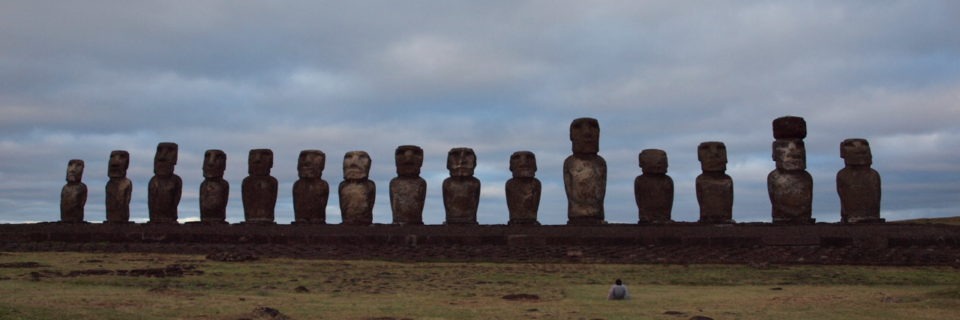
Lastly, with the sun just barely still peaking through the clouds, our guide took us to Tongariki. This is another very impressive presentation of ocean side Moai – the biggest on the island with 13 Moai lined up in a row. Only one of them is wearing a Pukao but apparently this was a restoration project funding by the Japanese that was never quite finished.

Tongariki